What is a Braided stream?
A braided river is one of a number of channel types and has a channel that consists of a network of small channels separated by small and often temporary islands called braid bars or, in British usage, aits or eyots. Braided streams occur in rivers with high slope and/or large sediment load.[1] Braided channels are also typical of environments that dramatically decrease channel depth, and consequently channel velocity, such as river deltas, alluvial fansand peneplains.Formation
 Braided rivers, as distinct from meanderingrivers, occur when a threshold level of sedimentload or slope is reached. Geologically speaking, an increase in sediment load will over time increase in the slope of the river, so these two conditions can be considered synonymous; and, consequently, a variation of slope can model a variation in sediment load. A threshold slope was experimentally determined to be 0.016 (ft/ft) for a 0.15 cu ft/s (0.0042 m3/s) stream with poorly sorted coarse sand.[1] Any slope over this threshold created a braided stream, while any slope under the threshold created a meandering stream or— for very low slopes—a straight channel. So the main controlling factor on river development is the amount of sediment that the river carries; once a given system crosses a threshold value for sediment load, it will convert from a meandering system to a braided system. Also important to channel development is the proportion of suspended load sediment to bed load. An increase in suspended sediment allowed for the deposition of fine erosion-resistant material on the inside of a curve, which accentuated the curve and in some instances caused a river to shift from a braided to a meandering profile.[1] The channels and braid bars are usually highly mobile, with the river layout often changing significantly during flood events.[2] Channels move sideways via differential velocity: On the outside of a curve, deeper, swift water picks up sediment (usually gravel or larger stones), which is re-deposited in slow-moving water on the inside of a bend.The braided channels may flow within an area defined by relatively stable banks or may occupy an entire valley floor. The Rakaia River in Canterbury, New Zealand has cut a channel 100 metres wide into the surrounding plains; this river transports sediment to a lagoon located on the river-coast interface.Conditions associated with braided channel formation include:
- an abundant supply of sediment[3]
- high stream gradient[4]
- rapid and frequent variations in water discharge[4]
- erodible banks
- a steep channel gradient
However, the critical factor that determines whether a stream will meander or braid is bank erodibility. A stream with cohesive banks that are resistant to erosion will form narrow, deep, meandering channels, whereas a stream with highly erodible banks will form wide, shallow channels, inhibiting helical flow and resulting in the formation of braided channels.[5]Examples
Extensive braided river systems are found in Alaska, Canada, New Zealand's South Island, and the Himalayas, which all contain young, rapidly eroding mountains.- The enormous Brahmaputra-Jamuna River in Asia is a classic example of a braided river.[6]
- Braided river system are present in Africa, for example in the Touat Valley.
- A notable example of a large braided stream in the contiguous United States is the Platte River in central and western Nebraska. The sediment of the arid Great Plains is augmented by the presence of the nearby Sandhills region north of the river.
- A portion of the lower Yellow River takes a braided form.[7]
- The Sewanee Conglomerate, a Pennsylvanian coarse sandstone and conglomerate unit[8] present on the Cumberland Plateau near the University of the South, may have been deposited by an ancient braided and meandering river that once existed in the eastern United States.[9]Others have interpreted the depositional environment for this unit as a tidal delta.[10]
Notable braided rivers in Europe:- Italy
- Tagliamento (Northeastern Italy)
- Piave (river)
- Brenta (river)
- Cellina
- Meduna
- Fella
- Magra
- Narew (Poland and Belarus)
Friday, August 14, 2015
Braided streams

Monday, August 10, 2015
What is Anthracite?
Coal 101: What is Anthracite?

Anthracite is a type of coal that is made almost entirely of carbon, and as a result is much harder than other forms of coal.
Its low pollutant content allows it to burn cleaner than other types of coal, according to United Coal Holdings (TSXV:UCL), an ability that makes it preferred in many applications. As a result, companies that mine it tend to advertise those capacities.
How is anthracite used?
Anthracite is mainly used for heating — while it’s difficult to burn, anthracite produces more heat than other varieties of coal. It is also a common charcoal ingredient. By itself, anthracite is used in steam-based power generators and in liquid form can be used to power internal combustion engines. Anthracite also plays a role in steel production, and is often used to make coal-fired food.
Despite these myriad uses, anthracite does have some disadvantages. For instance, it is quite expensive due to its high quality, and as such isn’t often used in power plants or as a replacement fuel for gasoline. It’s also difficult to ignite, though for industrial applications that barrier is easy to overcome.
Where is anthracite mined?
Anthracite is most commonly found in mountainous regions, as well as near volcanoes and in areas where earthquakes are the norm. Unsurprisingly, there is a large supply of anthracite in the Appalachian Mountains in the United States, with 6 billion tons in that region alone, as per United Coal. There are also reserves in the Rocky Mountains and the Andes.
In the US, Pennsylvania, which is located in the Appalachian region, is the state with the highest anthracite production, Coal Diver states. Though production declined precipitously in the late 1990s and early 2000s, the region still produces plenty of the fuel — in 2010, the figure was 1,842,857 tons of anthracite. That is a decrease from 1998′s record of 5,234,201 tons, but it is still a significant amount of anthracite.
Which companies mine anthracite?
- Reading Anthracite is a private Pennsylvania-based mining company that was established in 1871. It concentrates on the mining and distribution of anthracite for many purposes, and delivers standard or custom anthracite to industrial clients that need high-grade carbon. The company also provides products for space heating and water and sewage filtering.
Reading’s projects are surface-mining sites in Pennsylvania, and one of the company’s aims is to make sustainable reclamation plans for each of them. To date, its reclamation projects have resulted in wildlife sanctuaries, parks and housing developments.
- Blaschak Coal, also a private company based in Pennsylvania, was founded in 1937, acquiring its first mine in 1945. It is one of the top anthracite producers in the US, and produced close to 1 million tons of raw coal in 2012. It holds three mines and two processing facilities.
The company obtains land that was previously mined and reopens it for use in production. Like Reading Anthracite and other coal producers in the area, Blaschak ensures its projects are slated for reclamation after they close, turning them into forest land in most cases.
- Lehigh Anthracite, another Pennsylvania-based company, is a joint venture between Robindale Energy Services and BET Entities, both of which are privately owned. The company mines from the Mammoth, Forty-Foot, Primrose and Orchard seams at the Lehigh anthracite mine, which is the largest surface-mining permit in Pennsylvania. It processes its products on site and has the capacity to produce up to 500,000 tons of anthracite yearly.
Saturday, June 6, 2015
What is Oil Sands?
What is Oil Sands?
Alberta’s oil reserves play an important role in the Canadian and global economy, supplying stable, reliable energy to the world. Alberta's oil sands have been described by Time Magazine as "Canada's greatest buried energy treasure." But what is oil sand exactly?
 Oil sand is a naturally occurring mixture of sand, clay or other minerals, water and bitumen, which is a heavy and extremely viscous oil that must be treated before it can be used by refineries to produce usable fuels such as gasoline and diesel. Bitumen is so viscous that at room temperature it acts much like cold molasses. New technologies are increasing the treatment methods available to oil sands producers as more research is completed.
Oil sand can be found in several locations around the globe, including Venezuela, the United States and Russia, but the Athabasca deposit in Alberta is the largest, most developed and utilizes the most technologically advanced production processes.
Historically, oil sand was incorrectly referred to as tar sand due to the now outdated and largely ineffective practice of using it for roofing and paving tar (oil sand will not harden suitably for these purposes). Though they appear to be visibly similar, tar and oil sands are different;
- Oil sand is a naturally occurring petrochemical that can be upgraded into crude oil and other petroleum products.
- Tar is synthetically produced from coal, wood, petroleum or peat through destructive distillation, it is generally used to seal against moisture.
History
The earliest documented oil sands mining operation was set up in 1745 in northeastern France, with refining capabilities added in 1857.
In 1929, the Dominion of Canada issued a patent to Dr. Karl A. Clark for the hot-water extraction process for separating bitumen from oil sands. This process laid the groundwork for the large-scale methods used by today’s producers of Canadian oil sands. Read more.
Sunday, May 31, 2015
Thursday, May 28, 2015
What is Diagenesis? | Geology
Wednesday, May 27, 2015
What are shale oil, shale gas and oil shale?
What are shale oil, shale gas and oil shale?
 S.Batkhuyag. President Monationenergy (NGO), Doctor Of Science, Professor
G.Yondongombo. Executive Director Monationenergy (NGO), PhD
Oil shale is one of the most prolific hydrocarbon resources on earth. Massive deposits are found in a number of countries around the globe, including Australia, Brazil, China, Estonia, Israel, Jordan, and the United States. Preliminary geologic surveys and evidence from oil shale outcrops indicate that Mongolia may also have oil shale resources of a size and quality that are commercially viable. Today, only China and Estonia produce oil shale commercially. With the high price of oil, decline in world conventional oil reserves, and increasing competition for oil resources worldwide, many countries and oil companies are turning their attention to this significant source of oil as the next generation of petroleum supply. Mongolia may be favourably positioned to benefit from the development of oil shale.
The United States is recognized as having the largest oil shale deposits in the world, the richest of which are located in a reasonably small area of Colorado, Utah, and Wyoming, collectively referred to as the Green River Basin. Estimates of the total resource that could be conceivably recovered, exceeds 2 trillion barrels (277 billion tons) -- eight times the size of Saudi Arabia’s reserves. In recent years, interest in development of the U.S. oil shale resource has increased significantly. Major oil companies, such as Shell, Exxon, and Total, along with numerous independent energy companies are developing new technologies. Through the Energy Policy Act of 2005 the U.S. government opened lands for oil shale research and development leases, for both subsurface (insitu) and surface production technologies. In 2008 the U.S. Department of the Interior finalized Rules and Regulations for the potential leasing of approximately 2 million acres in Colorado, Utah, and Wyoming. Though they have been challenged on legal grounds, the regulations have set the stage for eventual commercial development.
Mongolia, like the United States, may have an opportunity to develop its potential oil shale resources. This is a resource of significant national importance, the development of which could provide Mongolia with energy security in addition to export market opportunities and secure high paying employment, including engineering and technical jobs, for many people. As with the United States, Mongolia requires all types of energy resources, both conventional and unconventional petroleum, to meet their respective needs. Often the distinction between certain resources are obscured or misunderstood.
In the United States and elsewhere in the world a great deal of attention has been given to shale oil and shale gas production. These resources should not be confused with oil shale, as will be explained later. A host of European countries are looking at the development of shale gas as a means to secure a measure of independence from natural gas imports. The United States has found more than 100 years’ supply of shale gas in the Marcellus and Barnett formations. Using similar technological advances, shale oil reserves such as the Bakken and Niobrara reservoirs are producing substantial quantities of oil.
None of these resources has the size nor production potential of oil shale. The potential for oil shale production is tremendous worldwide and for detractors and skeptics, it should be noted that it was not long ago that shale gas and shale oil were thought to be both technically and economically unproductive.
Aside from the fact that we are discussing oil and gas, as mentioned, this is where the comparison between shale oil/shale gas and oil shale ends. In recent trade journals and newspaper articles there has been confusion regarding the difference between oil shale and shale oil. In certain articles the terms are used incorrectly and often interchangeably, further confusing their distinction. There is a world of difference between the two resources; comparing them is not unlike confusing oil with coal, both of which are hydrocarbons, but strikingly different in composition and methods of production and synthesis.
By definition, oil shale is a petroleum precursor, which is organic matter in the rock called kerogen. By applying heat, it can be transformed into oil and gas. Shale oil, or “tight oil” is a conventional crude oil created naturally and trapped in shale deposits -- requiring modern drilling and recovery technologies to produce. Shale gas is similarly produced from shale deposits. Advances in drilling and secondary recovery technology in the past decade have allowed companies to produce conventional oil and gas from heretofore uneconomic shale formations.
Oil shale (kerogen) deposits are entirely different from shale oil deposits. They have not sustained the time and temperature required to turn the kerogen to crude oil. Only applied heat will convert oil shale to crude oil. What mother earth failed to accomplish with time, can be obtained by the application of man-made heat.
The oil shale production process involves only the application of heat. Unlike shale oil production, there is no requirement for elaborate long-reach horizontal drilling or fracturing of the rocks to allow flow paths through which the oil and gas will be produced. There is no water or chemical reagents used to facilitate the fracturing of the reservoir in the production of oil shale. In fact, subsurface water is produced and can be cleaned and used for other purposes.
The crude oil produced from oil shale is high in light ends and is a source of quality products such as diesel, jet fuel, motor gasoline and natural gas liquids. Like China and other neighbouring countries, Mongolia is blessed with this resource and if produced in a responsible way, it can be a major part of the energy portfolio of the country.
Further information on oil shale can be found through the National Oil Shale Association at
www.oilshaleassociation.com
Source
Brine Waters "Brines"
Natural brines are waters with very high to extremely high concentrations of dissolved constituents—elements, ions, and molecules. Brines are commonly considered to be those waters more saline, or more concentrated in dissolved materials, than sea water (35 grams of dissolved constituents per kilogram of sea water). Brine can contain salt concentrations more than five times greater than the salt content of average sea water. Natural mixtures of brines, sea water, and fresh waters occur at various locations.
Owing to high concentrations of dissolved components such as sodium and magnesium, brines are of commercial interest, especially in the production of table salt. Subsurface caverns (especially those used for the mining of table salt), saline lakes (e.g., the Great Salt Lake, the Dead Sea, the Salton Sea), and the saltwater ocean are three principal sources of brine. Despite their economic value in some circumstances, brines may cause considerable trouble where they leak into potable (drinkable) water supplies or contaminate water for animals, crops, gardens, and other landscaped terrains.
Formation of Ocean Brine
In the ocean, brine is formed by several processes: evaporation, formation of sea ice, and solution of salt domes.
Evaporation.
One of the more common processes is by evaporation. Evaporation is greatest in shallow or stranded regions of sea water, where the energy of the Sun evaporates some water, concentrating the salt. The process where the solvent(water) is removed from the system is known as evaporite formation, and the resulting rock is called an evaporite. Evaporites are common in the geologic record.
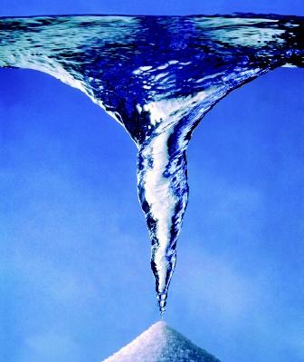
Brines are waters containing extremely high concentrations of dissolved constituents, including salt. This image conceptualizes the abundant salt that can be precipitated from a brine solution.
Sea Ice.
Another process by which ocean brines arise is through the formation of sea ice. As sea water begins to solidify, some of the saltier, denser water (brine) drains to underlying water. As the ice thickens, the brine can become trapped in pores known as brine pockets. This effect further concentrates the brine. Brine pockets are typically less than half a millimeter in diameter, but can extend downward into the ice for some distance.
The presence of brine pockets influences the mechanical properties of sea ice in ways that are not yet fully understood. As the ice structure changes, more water is extruded from the pores, increasing the salt concentration of the brine in the pore space up to eight times that of typical (liquid) sea water. At this extreme concentration, the sodium and chloride are supersaturated, and so begin to precipitate as salt crystals. Concentration processes in the ice pores may continue, resulting in a slurry or a gel. At very high salt concentrations, sodium chloride crystals (halite) form, as can crystals containing chlorides of other salts such as calcium and magnesium.
Salt Domes.
Brine can form by the aqueous solution of evaporite deposits such as those found in salt domes. A salt dome is a geological structure where very deep deposits of relatively "plastic" salt flowed upward through the bedrock owing to the great pressure of this overlying rock and sediment. The salt may break through the rock and sediment layer, protruding with a dome-like shape, thus giving the structure its name.
Salt domes are a distinctive feature of the Gulf of Mexico, in particular the central region of the gulf called the Orca basin. The solution at the bottom 150 meters (492 feet) of the Orca basin is not sea water but a highly concentrated brine with little or no free oxygen. A layer of salt formed at the Orca basin during the Jurassic Period of Earth's history. * The salt was eventually extruded, under tremendous pressure, through overlying layers of sediment toward the surface, forming salt domes. Oil and gas included in these sediments may be pooled and trapped by salt dome structures and form attractive targets for energy exploration.
There are more than 500 known salt domes in the Gulf Coast region. Some of these originate from the salt layers that are many kilometers underground. In the Orca basin, salt domes on the sea bottom expose the salt to the sea water. Where the salt dome interacts with the sea water, solution of the dome can occur as salt dissolves in water. The extreme salinity of the area immediately surrounding the salt dome, however, will create a pool of salt water that is denser than the surrounding sea. This extremely salty water, or brine, leaks from the area of the salt dome into surrounding depressions on the sea floor, creating brine pools.
Oil Seeps.
The presence of brine, such as in a brine pool, is useful in some regions as an indicator of the presence of an oil seep. Geological features that allow salt to protrude from the seabed in places such as the Gulf of Mexico also are conducive to the leakage of oil and natural gas: the Gulf of Mexico is a significant oil-producing region. The oil seeps in the gulf are common enough that oil slicks are visible from satellites in some places. Hundreds of oil drilling platforms are positioned offshore of Texas and the eastern coast of Mexico to explore these areas. *
Oil-Field Brines
Natural brines are commonly found at depth in the Earth, but they also are found at Earth's surface, most notably as a byproduct of oil and gas test wells and production wells; hence they are known as oil-field brines. As petroleum and gas is commercially produced, brines may be produced in large quantities. In oil fields that have been producing for long periods of time, such as in central and west Texas, wells may produce hundreds of barrels of brine for every barrel of oil.
How do these natural brines form? In most sedimentary rocks (the most common geologic host for oil and gas), the sediments and rocks formed in a marine environment and therefore incorporated sea water in their pores and other interstices. However, subsurface brines are not simply concentrated sea water. (Stranded arms of the sea commonly cause evaporite deposits, where evaporation of pure water from sea water in nearshore marine settings result in the deposition of salt and other evaporitic progeny of sea water, such as gypsum.)
Although the evolution of brines from sea water in sediments and sedimentary rocks is complex and not completely understood, it appears that several processes may be involved:
- Concentration of dissolved constituents through evaporation;
- Retention of dissolved materials through membrane filtration by clay and clay-like minerals;
- Deposition of solids such as halite, dolomite, and anhydrite from the waters;
- Solution of other minerals from adjacent sediment or rock;
- Exchange of cations (positively charged ions) between water and solids;
- Bacterial and other organic processes; and
- Other chemical processes.
Brine Disposal.
Oil-field brines must be disposed of in such a way that drinking waters and waters for other uses are not contaminated. Historically, brines would be dumped into a pit and commonly they would appear to "evaporate" or otherwise go away. In too many cases, however, the brines were simply seeping downward into the subsurface rocks, and contaminating the local aquifer . Because groundwater in most places moves slowly, perhaps several millimeters a year, many years might pass before nearby water wells became contaminated. Lawsuits commonly followed.
What is Permafrost
Permafrost
Permafrost is permanently frozen soil, and occurs mostly in high latitudes. Permafrost comprises 24% of the land in the Northern Hemisphere, and stores massive amounts of carbon. As a result of climate change, permafrost is at risk of melting, releasing the stored carbon in the form of carbon dioxide and methane, which are powerful heat-trapping gases. In addition, permafrost is structurally important, and its melting has been known to cause erosion, disappearance of lakes, landslides, and ground subsidence. It will also cause changes in plant species composition at high latitudes.
- What is permafrost?
- The Effect of Climate Change on Permafrost
- Melting Permafrost Causes Greenhouse Gas Emissions
- Carbon Exchange
- Methane
- Other Impacts of Melting Permafrost
- Conclusion
- Related Blogs
- References
- Further Information
What is permafrost?
Figure 1. Idealized permafrost cross section.
Permafrost is permanently frozen soil, sediment, or rock. Its classification is solely based on temperature, not moisture or ground cover. The ground must remain at or below 0°C for at least two years in order to be considered permafrost. Although new permafrost is forming, it can be over thousands of years old. For example, some of the permafrost in western Canada's boreal peatlands has been there since the Little Ice Age of the 1600's (Turetsky et al., 2007).
Permafrost has layers, of which frozen ground is just one portion (Figure 1). The active layeris ground that is seasonally frozen, typically lying above the perennially frozen permafrost layer. Talik is unfrozen ground that lies below the permafrost and between the active layer and permafrost.
Where is permafrost found?
Most frequently, permafrost is found in high latitudes near the north and south poles. However, it can also be found at high altitudes in other locations around the world. Roughly 37% of the Northern Hemisphere permafrost occurs in western North America, mainly in Alaska and northern Canada, but also further south in the Rocky Mountains. The majority of permafrost in the Northern Hemisphere occurs in the Eastern Hemisphere, in Siberia and the Far East of Russia, as well as northern Mongolia, northeastern China and the Tibetan Qinghai-Xizang Plateau (Zhang et al., 1999).
In the Southern Hemisphere, permafrost is found in Antarctica, the Antarctic islands, and the Andes Mountains. In areas where the conditions are such that the ground is cold enough year-round, continuous permafrost forms. Discontinuous and sporadic permafrost occurs in locations where temperatures only get cold enough in certain areas, such as in the shade, or on the northern side of a hill or mountain. Seasonal permafrost occurs during colder seasons and thaws or disappears during warmer times of the year.
The Effect of Climate Change on Permafrost
Climate change will significantly affect the complex interactions between above- and below-ground climate regimes. However, even changes in temperature at the surface take time to impact permafrost at depth; According to the Geological Survey of Canada (GSC), "for thick permafrost this lag may be on the order of hundreds to thousands of years, for thin permafrost, years to decades" (GSC, 2007).
In a recent study using freezing/thawing index, trend analysis of spatial data since 1970 indicates that in recent decades, there has been a decrease in freezing during the cold season throughout North America's permafrost regions. Additionally, coastal areas and eastern Canada have started to see "significant" increases in warm season thawing of permafrost (Frauenfeld et al., 2007). Overall, this means there has been a decrease in freeze depths and in the amount of permanent permafrost. Conversely, there has been an increase in seasonal permafrost. This increase in seasonal permafrost is not due to increases in acres frozen, but to the decrease in permanent permafrost which is not remaining frozen all year anymore. Since it is no longer perennially frozen, it loses its distinction as 'permanent' and becomes 'seasonal'.
Figure 2. Permafrost distribution in the Arctic. Image credit: Philippe Rekacewicz, 2005, UNEP/GRID-Arendal Maps and Graphics Library based on International Permafrost Association (1998) Circumpolar Active-Layer Permafrost System (CAPS), version 1.0.
Decreasing freeze depths have also been recorded in a separate study of deep boreholes in mountain permafrost in Svalbard and Scandinavia. Results from the study show that the permafrost has "warmed considerably" at the study sites and that "significant warming is detectable down to at least 60m depth, and present decadal warming rates at the permafrost surface are on the order of 0.04°.0.07°C [per year], with greatest warming in Svalbard and in northern Scandinavia. The present regional trend shows accelerated warming during the last decade" (Isaksen et al., 2007).
Although many studies, programs, and research, including the Global Terrestrial Network for Permafrost (GTNP), indicate a warming trend throughout the permafrost zone, some have found no significant changes have occurred in permanent Russian permafrost regions. According to the authors of the study mentioned earlier, spatial trend analysis shows that while permanent permafrost areas in Russia have remained largely within the same freezing regime, seasonally frozen ground areas are experiencing "significant warming trends" (Frauenfeld et al., 2007).
All of these changes in permafrost areas are attributed to increases in air temperature and changes in snow cover, specifically in Canada and Alaska. This echoes the conclusions of numerous other reports, such as those from the Geological Survey of Canada and the Arctic Climate Impact Assessment, which attribute the northern polar region's permafrost thaw to dramatic warming over the past half-century. In regions of discontinuous and seasonal permafrost, ground temperatures are generally right around freezing. With even 1-2 degrees increase in temperature, these areas of permafrost will "likely ultimately disappear as a result of ground thermal changes associated with global climate warming" (GSC, 2007). Based on trends and forecasts predicted by climate models, however, we could be facing a much steeper increase in air temperature, leading to more significant effects on permafrost regions across the globe. As Charles Harris, one of the authors of the Svalbard study, a geologist at the University of Cardiff, UK, and a coordinator of Permafrost and Climate in Europe (PACE), said in a 2004 interview, "Boreholes in Svalbard, Norway, for example, indicate that ground temperatures rose 0.4°C over the past decade, four times faster than they did in the previous century. What took a century to be achieved in the 20th Century will be achieved in 25 years in the 21st Century, if this trend continues" (Bently, 2004).
Additionally, thawing and warming permafrost areas do not seem to be reversing the trend from year to year. Instead, they keep warming. Researchers of Canada's peatland permafrost regions mentioned "The permafrost underlying Canada's peatlands show no sign of regeneration" (Turetsky et al., 2007). According to the IPCC, by the mid-21st century, the area of permafrost in the northern hemisphere is expected to decline by around 20 per cent to 35 per cent. The depth of thawing is likely to increase by 30 percent to half its current depth by 2080 (UNEP, 2007). The end result could look something like the scenario depicted in the figure "Map of Permafrost in the Future".
Impacts of Melting Permafrost: Physical and Ecological
Thawing permafrost has significant effects on surface and subsurface regimes, including those governing hydrology and energy and moisture balance. Ecosystem diversity, composition, and productivity are not only impacted by increasing air temperatures, but by the associated effects of increasing ground temperatures as well. Because of this, thawing permafrost has significant impacts on infrastructure and ecosystems. Where ground ice contents are comparatively high, permafrost degradation can have significant impacts, some of which may take not be as readily apparent as others.
Structural Importance
The Geological Survey of Canada states "Of greatest concern are soils with the potential for instability upon thaw (thaw settlement, creep or slope failure). Such instabilities may have implications for the landscape, ecosystems, and infrastructure" (GSC, 2007). Erosion, landslides, and subsidence can all result from permafrost degradation.
Figure 6. Sishmaref photo series: “Only two hours separate the first photo from the second. For reference, red arrows mark the barrel. By the time the second photograph was taken, the coastline in the foreground had retreated past the barrel. Although coastal erosion was significant, this was not a particularly strong storm. Image courtesy of Tony Weyiouanna Sr.” Image credit: NSIDC.
Erosion
Erosion is especially evident and worrisome in coastal areas, may of which are also being ravaged by winter storm surge as the protective barrier of sea ice appears later and later (if at all) during the year. Intact permafrost is extremely resilient. However, when it becomes compromised, it and the ground above and below it become much more vulnerable to the erosive forces of wind and water. On our Sea Ice page, you can see a picture of a house in Shismaref, Alaska that has had its foundation washed away by storm surge. These pictures to the right in Figure 4 were also taken in Shishmaref, Alaska, during a storm in 2003.
In some areas, erosion has been so much enhanced by exposed and degraded permafrost, the inhabitants might have to be evacuated. Costs to relocate are hefty . for towns such as Kivalina, Alaska, they have been estimated at upwards of $400 million. Due to the heavy toll climate change is taking on Kivalina, the town recently sued two dozen oil, power, and coal companies for their contributions to global warming (CNN, 2008).
Landslides
As permafrost thaws, the friction needed between the frozen and thawing permafrost regions to maintain stability disappears. On ice, you don't need a very sloped surface before you start to slip and slide . and that's exactly what happens with the permafrost and overlying land, resulting in landslides. This happened in July of 1988 on the Fosheim Peninsula of Canada's Ellesmere Island after a few years of increasingly warmer temperatures during the summers. Hundreds of landslides, some of which were the size of over three football fields, carried tons of soil into a number of creek valleys.
According to the Permafrost and Climate in Europe (PACE) project, thawing permafrost is likely to have similar effects on the slopes of Europe's Alps and Pyrenees as global temperatures continue to rise. Landslides, such as the Val Pola landslide of July 1987 in the Italian Alps are predicted to become more common as the permafrost underlying the slopes of Europe's mountains degrades due to rising ground temperatures.
Subsidence
Figure 7. Permafrost distribution in the Arctic. Image credit: Philippe Rekacewicz, 2005, UNEP/GRID-Arendal Maps and Graphics Library based on International Permafrost Association (1998) Circumpolar Active-Layer Permafrost System (CAPS), version 1.0.
Ground subsidence can occur when permafrost thaws and the soil previously held up by the ice collapses. The resulting landscape is characterized by irregular surfaces of marshy hollows and small hummocks called thermokarst. Visitors and residents all over permafrost regions have been struck by the effects of this phenomenon when they see a wooded landscape affected by subsidence from permafrost thaw. They call these areas "drunken forests" because of the way that the trees lean, as shown in Figure 5.
However, subsidence can have other effects on vegetation. A group of scientists studying the effect of permafrost thawing on vegetation in Alaska noted, "This effect of warming acts on vegetation indirectly by creating localized variability in moisture conditions as lower karst areas accumulate moisture and may have the water table near the soil surface, while nearby higher areas become drier" (Schuur et al., 2007). In some of these areas, these changing conditions allow new plant species to grow. In other pockets, water collects and they become thermokarst lakes or ponds. Once the underlying permafrost has thawed completely away, however, this water sinks back in to the empty space and disappears. According to a 2005 article in Science, this is what has been happening in Western Siberia, where thawing permafrost is the likely cause behind of the disappearance of Siberian Arctic lakes during the past three decades over an area of 500,000 square km (see Figure 6).
In addition to its ecological effects, subsidence caused by thawing can significantly compromise infrastructure built on top of permafrost. Many permafrost areas are permanently inhabited by humans, and as such have roads, buildings, and other structures built on it. In places where these structures were not designed to withstand changes in permafrost, subsidence has created sinkholes that swallow up houses and small buildings, and has also caused foundations to shift and drop and roads and railroads to crack and heave (such as the building and railroad in Figure 7 at right). In some permafrost areas, engineers are coming up with new ways to build on permafrost such that the ground is insulated from the heat created by whatever is on the ground above it. Additionally, these new engineering techniques are making it possible for the infrastructure built upon it to weather changes in permafrost a little bit better. The world's longest high-elevation railroad, the Qinghai-Tibet Railway or "Permafrost Express", in China and the 800-mile long Trans Alaska Pipeline in Alaska both involved engineering and design techniques sensitive to the permafrost environment in which they were constructed.
Figure 8. A railroad in Alaska (left) and building (right), both buckled due to thawing permafrost. Image credit: (left) NASA and U.S. Geological Survey, (right) Vladimir Romanovsky, Geophysical Institute, University of Alaska Fairbanks.
Ecology
The changes brought about by thawing permafrost will also have significant impacts on the ecosystems of the Arctic. In addition to impacting migration routes and patterns in birds, reindeer, and caribou, it is expected that the effects of thawing permafrost will change the plant species composition of the area, as well as its productivity.
Changes in plant species composition
Increasing temperatures are expected to have significant impacts on the species composition world wide. This is also true of permafrost areas in northern latitude ecosystems, where plant species composition and productivity will change as increasing temperatures will allow new, warmer-climate species to grow. Tundra is usually characterized by sedges and grasses. However, with warming temperatures, these typical tundra species are being overtaken by evergreen shrubs and trees. The IPCC projects that by 2100, between 10 and 50% of the Arctic tundra could be replaced by forests (UNEP, 2007).
Warming can affect plants directly, through its influences over plant growth, and indirectly, through changes in nutrient availability. In permafrost areas, where increasing temperatures and subsequent thawing causes the development of thermokarst, warming can drastically change the hydrologic profile of an ecosystem. Researchers working at permafrost sites across Alaska and at peatland sites overlaying permafrost across boreal regions in Canada found changes in community composition, biomass, and productivity as a result of warmer air and soil temperatures as well as associated changes in the hydrologic structure of the soil (Schuur et al., 2007; Turetsky et al., 2007). Plant biomass shifted away from traditional species to plants associated with warmer, wetter biotypes. Additionally, plant productivity increased due to improved availability of nitrogen and other nutrients from altered hydrological patterns caused by thawing permafrost.
As a warming climate allows snow and ice to thaw, and tundra species are replaced with evergreens, albedo changes. Instead of reflecting sunlight, the landscape begins to absorb more heat than it did previously, further increasing the warming and thawing trends in the area.
Conclusion
Not all ecosystems in permafrost regions will respond the same way. Turetsky herself cautioned in an interview earlier this year, "It will depend on the history of the permafrost and the nature of both vegetation and soils" (Physorg.com, 2007). The quantity, distribution, and composition of the organic matter in permafrost areas are important in determining their effect on emissions. Some permafrost, such as yedoma permafrost found mostly in northern and eastern Siberia as well as in smaller amounts in Canada and Alaska, have more concentrated carbon and methane stores than others.
Additionally, records and data for many regions are incomplete or of short-term duration, with the exception of Russia's long-term permafrost monitoring. There has been a push to extend current monitoring programs and enlarge their scope. Programs such as the Global Terrestrial Network for Permafrost (GTNP) are working to organize data collection so that there is a global network for detecting and monitoring changes in permafrost regions, and predicting climate change's impact on these affected areas. Advances in spatial analysis have contributed greatly, as evidenced by the research conducted for the 2005 article on Siberian lake methane emissions. You can even monitor permafrost thaw with Google Earth!
Subscribe to:
Posts (Atom)